Our LiDAR Team Can Save You Time And Money On Your Projects
 A Letter From Our President, Mr. Darren Lazan
“LiDAR is the future, and we’ve embraced it.” I am thrilled to announce a significant investment in our Aerial Operations capabilities with the introduction of state-of-the-art LiDAR drone technology.
This advanced tool will revolutionize how we offer topographic services, ensuring greater accuracy, increased efficiency, and unparalleled data insights for all your projects. We are committed to consistently enhancing our offerings, and with this latest addition, we will deliver unmatched value and results tailored to all your needs.
We genuinely believe that innovation is the key to progress. This investment is a testament to our belief in the power of technology and our unwavering commitment to your success.
Winter is coming, so if you would like to experience the full potential of this technology, contact us today to have your project flown before the snow flies.
Darren Lazan, President
 What Is LiDAR?
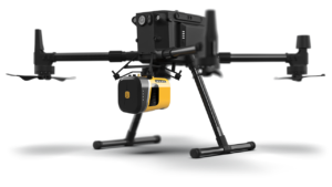
Landform’s LiDAR Operations team combines the latest, innovative drone technology with top-notch industry software to produce the premium content and results our clients not only seek but demand.
LiDAR is a remote sensing technology that uses laser pulses to measure distances to objects or surfaces.
LiDAR systems consist of a laser scanner that emits laser pulses and a receiver that measures the time it takes for the pulses to bounce back after hitting objects or surfaces.
The LiDAR Operation and Drone Operation teams use LiDAR for enhanced mapping and surveying applications. It can quickly and accurately measure the distances between objects or surfaces – creating a more comprehensive view of the environment for your projects.
How Do We Use LiDAR?
Depending on our client’s needs, the Landform Aerial Operations team uses LiDAR for various applications.
Here are some simple use cases for LiDAR and how we can use them for your projects:
- Mapping and surveying: LiDAR can create accurate, high-resolution maps of terrain, buildings, and other features. This can be useful for numerous industries, including urban planning, forestry, and agriculture.
- Construction and engineering: We use LiDAR for 3D models of terrain and site comparisons, and we create detailed 3D models of buildings, bridges, and other structures. This is extraordinarily useful for our clients, as it can help them visualize and plan projects more effectively.
Our team has industry-leading, professional expertise in LiDAR technology and can provide high-quality data and analysis for all of your projects and needs.
 Advantages And Benefits Of Using LiDAR
There are several advantages and benefits to using LiDAR, including the following:
- Accurate and precise measurements: LiDAR increasingly provides highly accurate and precise measurements of distance, which can be important for applications such as surveying, mapping, and construction. LiDAR can measure distances with a precision of a few centimeters, which is much more accurate than other remote sensing technologies. This can lead to more precise and reliable data, which can help improve decision-making and reduce errors.
- Improved visualization and analysis: LiDAR can create highly detailed 3D images of objects and surfaces, which can be helpful in applications such as urban planning, construction, architecture, and archaeology. 3D imaging can provide a more comprehensive view of the environment and allow for better analysis and planning.
- Increased speed and efficiency: LiDAR can quickly scan large areas and generate high-resolution data in a short amount of time. LiDAR can also help improve efficiency for our client’s projects, where accurate and timely data is essential for decision-making.
- Versatility: LiDAR can be used in various applications, including mapping, surveying, and construction. It can also be used in different environments, such as urban areas, forests, and oceans.
- Safety: LiDAR can be used to map and survey locations where traditional methods aren’t possible. It can also be used for safety inspections of infrastructure such as bridges and buildings, helping to ensure their structural integrity and prevent accidents.
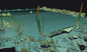
Our LiDAR Team In Action At Valleyfair
The Landform LiDAR Operations and Drone Operations teams executed an intricate topographic survey of the parking facilities at Valleyfair Theme Park, paired with a high-fidelity 3D model capture with our advanced LiDAR technology of the adjacent theme park. Click below to see the short video.
LiDAR Is More Accurate, Affordable And Efficient
Overall, the advantages and benefits of LiDAR provide our clients with more precise and accurate measurements, imaging, and detection capabilities. Learn more or contact us today to schedule a meeting or review a case study.